
Ice Road Pics
Subscribe
#21
Piece Of Work , 03-25-2007 04:12 PM
 01-20-2011
Amazing photographs, I envy you!
#22
Quote:
Thanks, I wish I could have got them a bit clearer. Naw, DON'T envy... It's just different...and damned COLD!! :lol: :lol:Originally Posted by Piece Of Work
Amazing photographs, I envy you!
 Wait this is a spur road...
#24
I have some more from my last trip across the MacKenzie Crossing last trip. The road was closed last Friday (thank God!) There was 2 FEET of water on the road & you could literally FEEL it moving underneith you. YIKES!! I think I held my breath most of the way (3.5 kms/2 miles) across! I told my dispatch that I wouldn't go again till the ferry was in the water unless he provided me with plontoons, an outboard motor & oars! :lol: :lol:
LadyNorth...PLEASE tell me how to post pics....
LadyNorth...PLEASE tell me how to post pics....
#25
Quote:
LadyNorth...PLEASE tell me how to post pics....
You need a site to host the pics and then hit the ing button, insert the site name and hit the img button again.Originally Posted by wildkat
I have some more from my last trip across the MacKenzie Crossing last trip. The road was closed last Friday (thank God!) There was 2 FEET of water on the road & you could literally FEEL it moving underneith you. YIKES!! I think I held my breath most of the way (3.5 kms/2 miles) across! I told my dispatch that I wouldn't go again till the ferry was in the water unless he provided me with plontoons, an outboard motor & oars! :lol: :lol: LadyNorth...PLEASE tell me how to post pics....
insert image:
#26
Lady North is at work tonight. Open up a Poto Bucket account, download pics, left click to highlight the image code, right click to copy, come on here and right click paste. Presto ! How far up that road do you go Wild cat ? Been there myself. Very interesting at times :shock:
#27
Quote:
I was on the Lupin Mine road..all the way..and on the Mackenzie Highway going to Yellowknife (my regular run) most everyday. I try to stay out of the Yukon, we don't do alot of work there & have some o/o based around there (Whitehorse, FSJ) for that. You live in John?Originally Posted by COLT
Lady North is at work tonight. Open up a Poto Bucket account, download pics, left click to highlight the image code, right click to copy, come on here and right click paste. Presto ! How far up that road do you go Wild cat ? Been there myself. Very interesting at times :shock:
#28
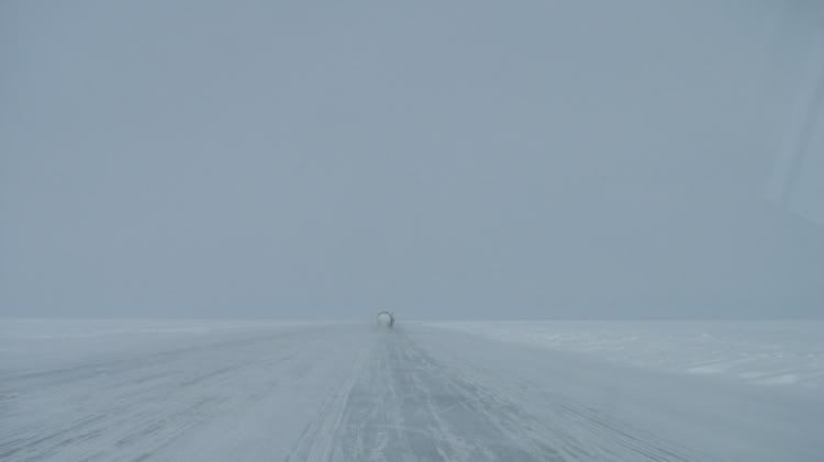
I have updated the photobucket with some recent photos. As you will see there was ALOT of water on the ice. Two feet deep in places. I had water marks 1/2 way up my fuel tanks! And was making a "wake" just like a boat. LOL :roll:
The pilons in one of the photos marks a HUGE hole!
The pilons in one of the photos marks a HUGE hole!
#29
Yep John. When you said Mackenzie crossing, I thought of the one north of F.T. Simpson. That road turns to winter road @ Wriglely, goes up to Norman Wells and Colvile lake etc. It's an interesting trail. Last year I was up that way, hang a left @ a place called Little Smith (a hill) cross the Mac again there and into the mountains we go... Next year, I'll be up there lots. It's very easy to post pics from photobucket...
#30
Quote:
Yep, there's a few crossings in the winter on the MacKenzie. I know the one you are talking about...one of the most hated roads in the NWT! :lol: Originally Posted by COLT
Yep John. When you said Mackenzie crossing, I thought of the one north of F.T. Simpson. That road turns to winter road @ Wriglely, goes up to Norman Wells and Colvile lake etc. It's an interesting trail. Last year I was up that way, hang a left @ a place called Little Smith (a hill) cross the Mac again there and into the mountains we go... Next year, I'll be up there lots. It's very easy to post pics from photobucket...
I was only on that one once..one too many for me.
The Provedence crossing is at least a "road" not a goat (ummm cariboo) trail!

